|
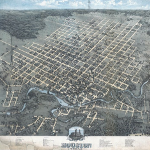
Bird's Eye View of the City of Houston Texas
|
1873
|
Birdseye view. Original not in the collections of the Harris County Archives. Includes numbered references to public buildings, churches, utilities, manufacturers, banks, and railroad depots.
|
|
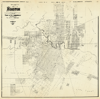
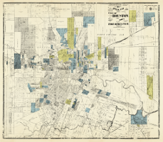
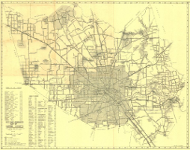
Official Map of the City of Houston and Adjoining Surveys
|
1890
|
Compiled from the Records of Harris County by Porter, Pollard & Ruby, Abstractors of Titles, Real Estate and Insurance Agents. Published by AugGast Bank Notes & Litho. Company, St. Louis. Original Map size 155 x 173 inches. Includes block numbers, names of additions and surveys, ownership, public buildings, cemeteries, railroads, businesses. Map conserved 2014 with funding from Stan Stanart, Harris County Clerk.
|
|
|
|
In addition to the 1890 unified map, the map can also be viewed in six panels.
1890 Official Map of the City of Houston Panel 1
1890 Official Map of the City of Houston Panel 2
1890 Official Map of the City of Houston Panel 3
1890 Official Map of the City of Houston Panel 4
1890 Official Map of the City of Houston Panel 5
1890 Official Map of the City of Houston Panel 6
|
|
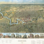
Houston, Texas (Looking South)
|
1891
|
Birdseye view. Original not in the collections of the Harris County Archives. Includes a Directory of Public Buildings, Hotels, Railroads and leading Manufactories and a Church Directory according to denomination and race. Illustrations of the Land and Trust Bank, Electric Power Station of the Houston City Street Railway Company, A. Hampe Dry Goods and Millinery, City Hall and Town Market, Harris County Courthouse, Houston Cotton Exchange. C. C. Gibbs Office Building form the bottom boundary of the map.
|
|
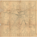
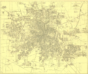
Houston, Street Guide
|
1904
|
Copyright by P. Whitty, Surveyor. Original size 22.5 x 22.5 inches.
Includes city wards, bayous, cemeteries, railroads, significant public and private buildings, and a street key.
Conserved 2008.
|
|
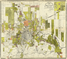
Official Map of the City of Houston and Vicinity
|
1907
|
Compiled and copyrighted by Stewart Abstract & Title Company. Engraved and Printed by State Printing Company, Houston, Texas. Original map size 226 x 198 inches. Includes block numbers, names of additions and surveys, ownership, parks, public buildings, cemeteries, railroads, businesses, street index. Houston Heights, Harrisburg. Map conserved 2014 with funding from Stan Stanart, Harris County Clerk.
|
|
|
|
In addition to the 1907 unified map, the map can also be viewed in six panels.
1907 Official Map of the City of Houston Panel 1 - position 1
1907 Official Map of the City of Houston Panel 2 - position 2
1907 Official Map of the City of Houston Panel 3 - position 3
1907 Official Map of the City of Houston Panel 4 - position 4
1907 Official Map of the City of Houston Panel 5 - position 5
1907 Official Map of the City of Houston Panel 6 - position 6 |
|
Houston Title Guaranty Co. City of Houston Texas
|
1913
|
A map compiled from photographs of map records, deed records and other official records of Harris Co., Texas. B. J. Dreesen, Draftsman. Copyright Houston Title Guaranty Co. Original map size 200 x 193 inches. Includes block numbers, names of additions and surveys, ownership, parks, public buildings, cemeteries, railroads, businesses, street index. Houston Heights, Harrisburg. Map conserved 2014 with funding from Stan Stanart, Harris County Clerk.
|
|
|
|
In addition to the 1913 unified map, the map can also be viewed in four panels.
Houston Guaranty Panel 1 - position 1
Houston Guaranty Panel 2 - position 2
Houston Guaranty Panel 3 - position 3
Houston Guaranty Panel 4 - position 4 |
|
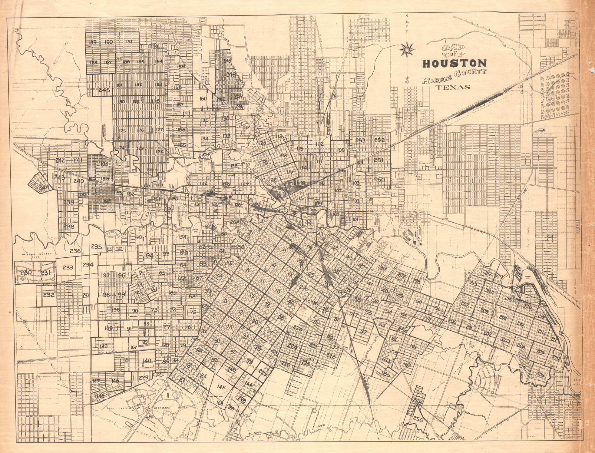
Map of Houston
Harris County, Texas
|
1928
|
Index map for Bracey’s Block Book of Houston. Originally bound in the front of the volume, the deteriorating map was removed and scanned. The original map size is 20 x 15 inches. The city map of Houston including the now annexed Houston Heights, is overlaid with squares corresponding to page numbers in the block book. The map contains basic information including streets, railroads, public facilities and schools. Of interest are the Rice Institute and George Herman Park. Greater detail is on the individual block pages.
|
|
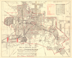
Map of Houston, Texas
|
1928
|
Compiled from data furnished by City Engineer’s Office and City Planning Commission. Drawn by Neil Geisenhoff. Compliments of Fantham and Fantham, real estate developers. Original map size 22 x 17 inches. May have been created for visitors to Houston for the National Democratic Convention. Identifies location of 1928 National Democratic Convention and Houston boundaries of from 1838 - 1928. Chart for telephone, gas, electric connections, and population 1916 - 1928. Major Streets, parks, and neighborhoods are identified.
|
|
Map of the City of Houston.
|
ca. 1940
|
Not dated. Drawn and Compiled by Leslie E. Ogilvie, Jr. Compliments of Wald Transfer and Storage Company. Original size 24 x 19 inches.
Front of Map includes city limits, railroads, boulevards, U. S. highways, state highways, parks, cemeteries, and block numbers. Insert map of Downtown Houston with an index and key to office buildings, public buildings, churches, and theaters.
|
|
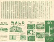
Back of Map.
|
|
Back of Map includes the street index, a chart showing real estate activity in Harris County 1924 - 1947, a letter from M. H. James, and advertising for the reality business.
|
|
Ashburn's 1947 Houston City Map.
|
1947
|
Copyright by J. Foster Ashburn, 414 West Bldg, Houston, TX. Compliments of M. H. James and Associates. Original size 28 x 20 inches. Front and Back.
Front of Map includes all bus routes and bus line names marked in red. Houston City Limits are shown and neighborhoods and subdivisions identified. Insert maps of the outlying communities of Galena, Pasadena, South Houston, Bellaire, West University, and Sunnyside.
|
|
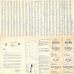
Back of Map.
|
|
Back of Map includes the street index, a chart showing real estate activity in Harris County 1924 - 1947, a letter from M. H. James, and advertising for the reality business.
|
|
City Map Company's Map of Harris County
|
1957
|
Copyright by R. L. Bayer, 5313 South Park Blvd, 1957. R. M. Stene, Cartographer. Revisions by Paul S. Ciolli. Original size 29 1/2 x 24 1/2 inches. (Map of Houston on reverse)
County road map with road conditions and indexes to map information including oil fields, towns, adjoining border towns, miscellaneous attractions, Houston city streets, and county roads.
|
|
City Map Company's Map of Houston - "Houston's most up to date map."
|
1958
|
Copyright by R. L. Bayer, 5313 South Park Blvd, 1958. Revisions by Paul S. Ciolli. Original size 29 1/2 x 24 1/2 inches. (Map of Harris County on reverse)
Map of Houston with outlying communities. City limits indicated along with major industrial plants, parks, cemeteries. No street index.
|
|
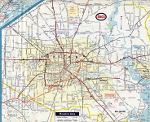
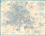
Houston Area Travel Map
|
ca. 1967
|
n.d. Travel map of Houston distributed by Humble Oil Company. Major roads and freeways, attractions, locations of Enco Service Stations and Humble Oil operations indicated.
Note on date: The date for the map was estimated using information from Houston Freeways by Erik Slotboom, © 2003, pg. 276
|
|
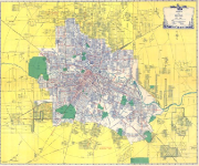
Clear Lake City Area Map
|
1968
|
Residential, Educational, Commercial, and Industrial Areas Under Development overlaid on an aerial map of the Clear Lake City area. Key identifies class of development. Residential subdivisions are identified.
|
|
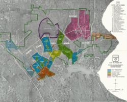
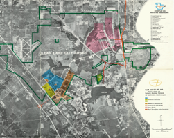
Clear Lake City Area Map
|
1973
|
Residential, Educational, Recreational, Commercial, and Industrial Areas Under Development overlaid on an aerial map of the Clear Lake City area. Key identifies class of development.
|